If anyone else in the San Francisco Bar area is interested in seeing The Lowest Pair at Doc's Lab on September 8th, drop me a note here or via email (see my Profile). I'd love to meet up with some of you and enjoy the evening together.
I know...bluegrass/roots music isn't for everyone, but this is the group I can't stop playing lately. Summer tends to pull me back to my redneck roots. Plus Kendl Winter was nice enough to answer some questions I had about lyrics and references to Richard Brautigan. Short answer: Yes, the references are there. Nice to know I haven't hit complete dotage yet. Although I'm pretty sure it won't be long...
Update: Looks like I'll be going to their Santa Cruz show on September 11 instead. They keep adding dates, so be sure to check their website for changes and additions.
Update: An interview with the group at The Grateful Web, which includes a writers they enjoy.
Thursday, June 30, 2016
Richard Brautigan, The Lowest Pair, and Thou

Tuesday, January 13, 2015
Pulgas Water Temple

Photo by Dwight Green
Another post on a local spot I like...
Located in Woodside, California, the Pulgas Water Temple commemorates the completion of the Hetch Hetchy Aqueduct (more on that below). The original temple, erected in 1934, was replaced four years later with the current structure of fluted columns supporting a ring inscribed with words from Isaiah 43:20: "I give waters in the wilderness and rivers in the desert, to give drink to my people." There is another plaque near the base with the same inscription.
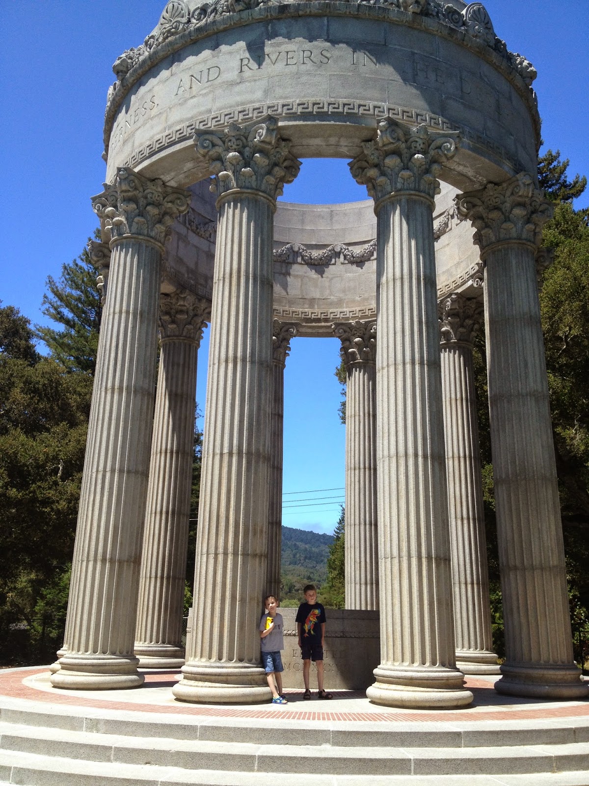
Photo by Dwight Green
I include this picture with the boys so you get a sense of scale. While the structure is huge, its size fits perfectly with the surrounding landscaping. East of the temple is a tree-lined reflection pool and a raised flowerbed (with the surrounding knolls just beyond the temple grounds).

Photo by Dwight Green
Water no longer flows into the water temple. The aqueduct now ends at a treatment plant a few hundred yards south of the temple. Before the redirection, over two billion gallons of water from the Sierras would flow into a tile basin underneath the temple, then emptied into nearby Upper Crystal Springs Reservoir.

Photo by Dwight Green
While there is a parking lot near the water temple, it's only open on weekdays. On weekends you either have to bike or hike to the temple grounds. My first visit there was after a 4-mile Sunday hike. I emerged from the surrounding woods to hear a string quartet playing at the temple. I sat nearby and watched a baptism...sometimes you get lucky on your timing. It has affected the way I've always looked at the place ever since then. It's a beautiful, peaceful place to visit.
So let's back up a step...why the aqueduct?

Photo by Dwight Green
After the 1906 earthquake and fire, San Francisco officials began looking for more adequate water supplies. They applied to the U.S. Department of the Interior for development rights of the Tuolumne River in Hetch Hetchy Valley. An act of Congress was needed, though, since the valley lay in Yosemite National Park. John Muir vigorously fought that approval, believing the Hetch Hetchy Valley to be more beautiful than Yosemite Valley. Muir died the year after the Raker Act was passed in 1913, which allowed flooding of the valley and construction of a dam. (For more on the repeated violations of the Raker Act by the city and Pacific Gas & Electric see this chronology).

Photo by Dwight Green
The dam was finished in 1923 and the aqueduct system completed in 1934. Crystal Springs Reservoir, where the water from the valley used to flow, is closed to the public but several trails wind around parts of the two reservoirs.

Picture source
Signs of the aqueduct system can be found all around the bay area. For example, if you've ever been to Great America in Santa Clara, you've walked right over one spur of the aqueduct (it crosses under the parking lot between Levi's stadium and the amusement park).
Sidenote: there's also a Sunol Water Temple located in the San Francisco Bay area, which may be the subject of a separate post.
I need to find a good book on the history of California water rights. What little I've read on it is fascinating. (See the post on California Water Wars for just some of the fun.)
The pictures of the Pulgas Water Temple were taken in July 2013. The pictures around Hetch Hetchy Reservoir were taken in January 2014.
Update (29 Dec 2018): Smarthistory has a short video on Albert Bierstadt's painting Hetch Hetchy Valley, California and a little bit on the history of the valley that is now underwater.
Saturday, December 27, 2014
Drawbridge, California

In my previous post mentioning Saltscapes: The Kite Aerial Photography of Cris Benton , I posted one of Benton's pictures of Drawbridge, California. I toured the ghost town, located in San Francisco Bay, in 1997. I thought a post on the history of Drawbridge might interest some of this blog's readers. The scans of a few pictures I took aren't great, but they give an idea of the surreal nature of visiting a ghost town located in the San Francisco Bay. For better pictures, click on some of the links below, especially Shawn Clover's page.

Drawbridge had an inauspicious beginning. In 1876, the South Pacific Coast Railroad worked on completing a railway between Alameda and Santa Cruz. San Francisco area residents could now travel to Santa Cruz in only a few hours at a fraction of the cost of a two-day stagecoach ride. One island posed a problem for the rail line: the sloughs on the north and south ends of the island had to remain open for shipping. Drawbridges were placed at each end of the island that could be opened for passing boat traffic and a cabin erected for the bridge tender to live. Station Island had its first resident.

In an ironic move in 1887, the South Pacific Coast Railroad, started as an alternative to the powerful Southern Pacific Railroad, was sold to the larger group. The island became an official stop with the name of Drawbridge. Before the advent of nearby salt ponds and the expansion of nearby cities, the southern end of the San Francisco Bay teemed with wildlife. Hunters began stopping at Drawbridge and eventually erected cabins and gun clubs. Soon permanent residences were built on either side of "Main Street," the railroad line running down the middle of the island.

The Prohibition era also helped make Drawbridge a popular destination. Located on the Alameda and Santa Clara County lines and not easily accessible, the island was usually left to itself by law enforcement officials. A hotel was built. In 1926 there were five passenger trains passing through the little island with 90 structures.

Expansion of nearby salt evaporation ponds, the pumping of fresh water from the underlying water table (for both the island and nearby growing cities), and the dumping of sewage into the bay changed the environment dramatically. Wildlife departed. Cabins began sinking. People abandoned the island. The last resident left in 1979 and the remaining structures slowly sink into the pickleweed and cordgrass. There used to be guided tours of the island, but they were discontinued in 2000. I can't express the eerie feeling of touring the island and its sinking structures framed by the bay. The U.S. National Wildlife Refuge governing the island decided to let the structures deteriorate as part of its wetland reclamation program.

Links:
- Wikipedia entry
- The Soft Underbelly of San Jose site has plenty of information on Drawbridge, using Drawbridge, California - A Hand-Me-Down History by O.L. "Montey" Dewey as a primary source (as did I). This booklet is recommended for anyone interested in the history of the town.
- Shawn Clover's photos are remarkable. If you follow only one link, make it this one.
- Photos of Drawbridge by David J. Young from earlier in 2014
- March 25, 2010 article at SFGate

Friday, December 26, 2014
Saltscapes: The Kite Aerial Photography of Cris Benton

Our wonderful local bookstore, BookSmart, had a 20th anniversary sweepstakes recently. I ended up winning a copy of Saltscapes: The Kite Aerial Photography of Cris Benton (Heyday, 2013). It is a fabulous book with beautiful photographs of the south San Francisco Bay area, where some of the industrial salt evaporation ponds are being restored to their original marshland state. For over a decade I worked next to the bay and would walk among the sloughs when I wanted to take a break. It's a lovely area and these photographs show some of the beauty and the otherworldliness (at times) of the setting. I'm so glad I won the book and highly recommend it.
Links
- The books' publisher page
- Be sure to check out the PDF excerpt link from the publisher
- An interview with Benton and photos from the book at Berkeleyside
- More on Benson's kite aerial photography, with useful links
- Hidden Ecologies, a collaborative project Benson is involved in, including more fascinating links

Picture source
The book has inspired me to do a post on Drawbridge, California, a ghost town in the San Francisco Bay that I toured in 1997. More on that in a few days...